The U.S. Interstate Highway System has been lauded as one of the greatest public works projects in human history. Encompassing nearly fifty thousand miles of standardized, limited-access highways, the system radically remade the built environment in the U.S. by connecting cities and making possible the massive suburbanization of the metropolitan landscape. But Interstate Highways also served to disconnect and disempower. Planners hoping to reinforce racial segregation routinely sited highways either through the heart of black and Latino neighborhoods or along boundaries between those communities and white ones. As a result, hundreds of thousands were evicted, thriving black and Latino neighborhoods were destroyed, and damaging color lines were reinforced. Following president Biden’s ambitious Infrastructure Plan which commits funding for reconnecting neighborhoods that were cut off, bulldozed, and blighted by urban renewal-era highways, we are at a critical moment in time to call into question the future of an outdated mobility infrastructure ripe for architectural and urban reimagining.

The research begins by taking a national view of the highway system to inventory and compare them with each other. 16 highways have been chosen that are all serious candidates for reimagining. All highways are in relatively high-density inner-city sites which have neighborhoods & communities that have historically been devastated by highway construction. For some sites, a conversation about reimagining their highway has just started, and for others, significant progress has been made. All could capitalize on the funding set aside by president Biden’s Infrastructure plan. By spatially documenting and critically mapping these key sites across the US, the research sets up the potential for highway interventions that speculate on the spatial & urban future of an outmoded mobility infrastructure. In doing so, it sets the framework to question and restructure our cities evolving relationships with their highways in the coming decades.

+
expand
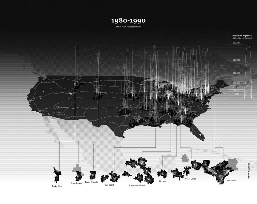
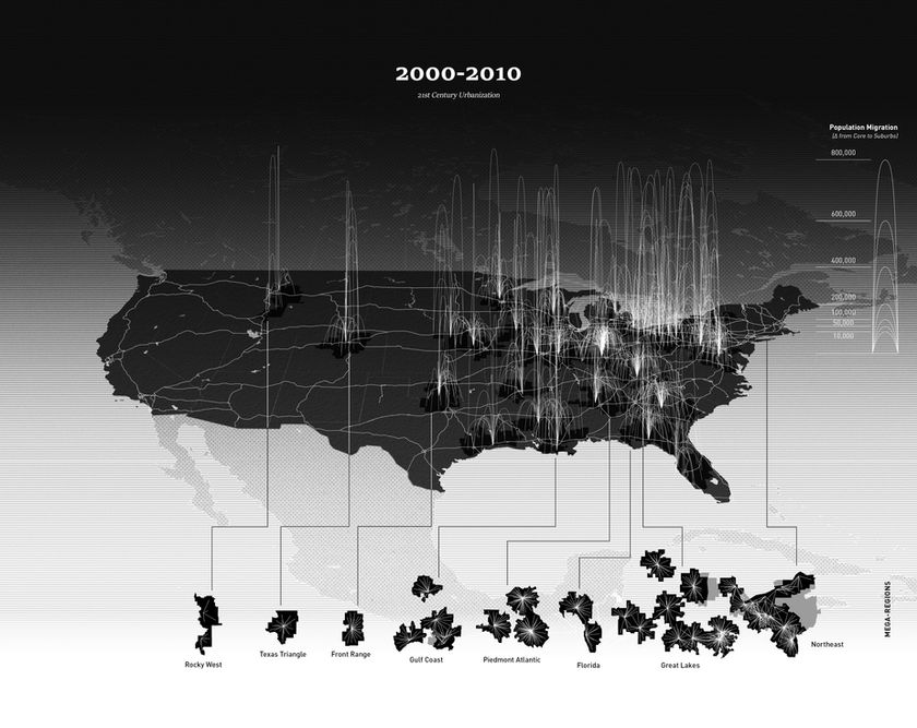
The timeline mappings below illustrate how the implementation of the Eisenhower Interstate Highway System radically reshaped the US’s metropolitan landscape by enabling large-scale migration, and was particularly instrumental in the era of massive suburbanization, white flight, and the clustering of urbanization patterns into the major US Mega-regions. Between 1950 and 1990, the aggregate population of 1950 geography central cities in the United States declined by 17 percent despite population growth of 72 percent in metropolitan areas as a whole. Our data visualization demonstrates how the construction of new limited-access highways contributed markedly to this central city population decline. Empirical estimates in our data imply that each new highway caused central city population to decline by about 17 percent, and suggests that had the interstate highway system not been built, aggregate central city population would have grown by 8 percent instead. By isolating population net decline of city centers with the net increase of regional counties that new highways created access to, the mappings demonstrate how urban transportation infrastructure played a key role in enabling the mass suburbanization and spatial distribution/forming of the US Megaregions in the past decades.
+
expand
The second part of this research pivots toward developing a typological and spatial toolkit that will begin to speculate on design interventions that move the contemporary conversations on highway infrastructure past just large-scale infrastructural decking or removal (where much of the discourse currently lies) and speculate on adaptive re-use, conversion or transformation of an outmoded infrastructure ripe for urban and architectural reinvention.
Indexed as a matrix of design strategies that investigate a range of typological forms against a set of existing highway spatial conditions (sunken, bermed, elevated, at-grade, intersection), this exploration suggests how design strategies at the architectural scales can intervene in these complicated infrastructural contexts, engaging in multi-scalar strategies and methods for catalyzing larger urban and landscape conversions.
The failure of Biden’s Infrastructure plan in the past few years to gain broad bipartisan support has led to a large reduction in the initial $20 billion in funding allocated to highway removals and illustrates the downside of thinking about highways in finite states: either through complete removal or large-scale capping/burial – both of which require tens of billions in funding. Rather, this spatial matrix of typological strategies argues that developing a typological kit-of-parts approach to potential interventions, which may demand far less gross funding, might act as a catalyst for the larger rescaling of infrastructure and reconnect communities through key sites & interventions (akin to pilot projects) that would then be able to spark larger investments through both wider public & private funds.
BAR
MATTE
SLAB
TOWER
COURTYARD
SUNKEN


BERMED


AT-GRADE


INTERSECTION


This typological matrix is then deployed on the site-specific contexts of each of the 16 highway candidates ripe for re-examination. Pictured here, the transcontinental I-10 freeway slices through the center of the city of LA and terminates it’s western end at the Pacific Ocean where it becomes the PCH (pacific coast highway). One of the very few E-W corridors of high-speed transportation in a city of sprawl, the I-10 plays a key role in both orienting and facilitating connections between the other freeways of the region as well the neighborhoods it divides, particularly its role in the decimation of the historic Sugar Hill neighborhood in LA.
Deployed on the diverse sectional conditions and local contextual neighborhoods along the I-10 that have historically bared the burden of the freeway's negative externalities, this aggregation of multiple typologies stitch an outmoded mobility infrastructure back to its urban fabric. These deployments suggest a bottom-up approach to developing adaptive-reuse spatial interventions that might catalyze larger urban & landscape conversions and that have the potential to completely restructure our cities relationship with their highways.

+
expand
Zooming further into one of these site-specific typological contexts in an urban center, the speculation below explores a multiple-phase scenario in which a highway is adaptively converted from a negative community dividing infrastructure that serves only single-occupancy vehicles, into a positive multi-functional infrastructure that fosters multi-modal shared forms of mobility, community empowering social spaces and amenities, and environmentally sustainable outcomes.
Enabled by the implementation of shared & autonomous forms of transit that eliminate the space-demands of cars, the speculation lays out mobility, social, and environmental strategies that provide a roadmap for the transformation of a highway, the local streets, and the community it bisects. In conjunction with targeted highway-segment removals and new development & open space typologies, the strategy stitches the infrastructure to its surrounding urban fabric and lays the foundation for new investment that ensures long-term affordable and culturally-diverse improvements that benefit, rather than displace, the existing community.

+
expand

+
expand
This research was invited to be curated as part of the Mediating Data exhibit that was on display from April 7th - April 28th, 2023 at the East Gallery of Campbell Hall in the University of Virginia (UVA). Mediating Data is an exhibition of projective cartographic mapping, augmented and virtual reality hybrid models, and experimental data/graphic systems developed by faculty at the UVA School of Architecture. The projects explore how an emergent conceptual synthesis of established methodologies and contemporary digital tools contributes to new and developing subjectivities within the design disciplines. The exhibition will highlight projects in five categories: Digital Cartographies; Sensing and Proxying Data; The Expanded Field of Drawing; Tools and Interfaces; and Augmented Representation. The Future of Highways Research project was exhibited as part of the category of "Digital Cartographies".


